GeoPlan Infrastruktur GmbH applies cutting-edge GIS and data analysis to drive awareness and solutions for critical environmental and urban challenges facing communities across the Rhine-Main area. We leverage precision geospatial intelligence to build stronger, safer, and more sustainable urban environments.
Learn How You Can Help
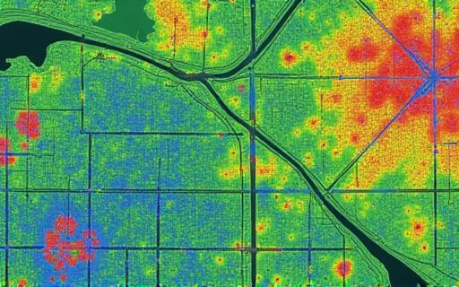
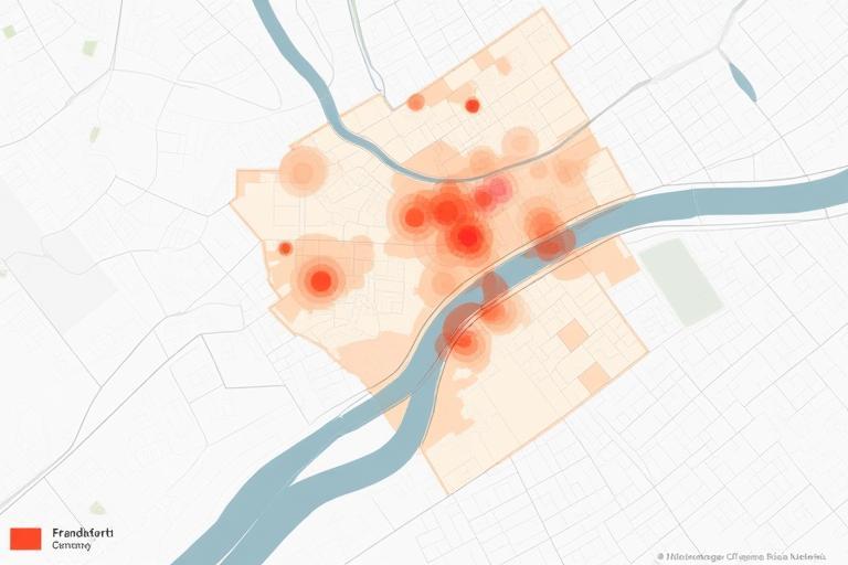
The Rhine-Main region, centered around the vibrant metropolis of Frankfurt, faces a confluence of pressing challenges driven by rapid urbanization and the undeniable impacts of climate change. Our dense urban areas and critical infrastructure are increasingly vulnerable to extreme weather events, including intense heatwaves and devastating floods along the Main and Rhine rivers. Simultaneously, aging infrastructure and the pressures of population growth strain existing systems.
Effectively addressing these complex issues requires more than traditional planning; it demands a deep, spatially-aware understanding of our environment. Where are the most vulnerable communities located relative to flood zones? How does urban design contribute to heat island effects? Where are the critical utility lines most at risk from severe weather? Without precise, integrated geospatial data, decision-makers are often working with incomplete pictures, leading to less effective and poorly targeted interventions. This challenge necessitates collaborative efforts and precise, data-driven solutions to mitigate impact and build enduring resilience for the future of our communities.
GeoPlan Infrastruktur GmbH brings decades of expertise in digital mapping, GIS, and data analysis to provide actionable insights and tools for urban resilience initiatives. We translate complex spatial data into clear strategies that empower city planners, environmental agencies, and infrastructure operators.
Creating highly accurate, high-resolution digital maps of affected areas, critical resources, and intricate infrastructure networks. Using techniques like LiDAR and aerial photogrammetry, we build detailed 3D models and base maps that reveal subtle topographical features, building footprints, and utility corridors essential for precise planning and risk assessment. This provides the foundational geospatial intelligence needed to see the urban environment with unprecedented clarity.
Utilizing sophisticated Geographic Information Systems, we perform complex spatial analyses to understand patterns, model potential scenarios, and identify areas most in need of intervention. This includes simulating flood inundation based on elevation and river flows, modeling the dispersion of heat in urban canyons, analyzing infrastructure interdependencies, and identifying optimal locations for new green spaces or emergency facilities. Our analysis transforms raw data into actionable intelligence.
Collecting and processing data from a variety of sources, including satellites, drones, and ground-based sensors, allows us to monitor environmental conditions and infrastructure changes in near real-time. This provides up-to-date information crucial for tracking the progress of resilience initiatives, assessing the impact of events, and adapting strategies dynamically. Our monitoring capabilities ensure that planning remains responsive to evolving conditions on the ground.
See how our geospatial expertise translates into meaningful progress on the ground, helping to make communities in the Rhine-Main region stronger and safer.
Sq KM Mapped for Critical Assessment
Detailed Vulnerability Assessments Completed
Improvement in Partner Data Accessibility
Our detailed geospatial mapping and ecological analysis helped identify key biodiversity hotspots and sensitive green corridors within and around urban areas like the Taunus foothills near Frankfurt. This precise data was instrumental in advocating for and establishing protected status for specific natural areas, ensuring their preservation against development pressures and enhancing their role in urban climate regulation and biodiversity conservation.
Through advanced GIS analysis and infrastructure mapping, we developed sophisticated flood risk models for municipalities along the Main river. This analysis not only identified vulnerable areas and assets but also informed the strategic placement of emergency resources and optimized evacuation routes. The detailed spatial insights provided city authorities with the information needed to create more effective disaster response plans, potentially saving lives and reducing damage during future flood events.
GeoPlan Infrastruktur GmbH is committed to leveraging our expertise for public benefit. While we are a commercial entity, we dedicate resources to support initiatives like advancing urban resilience. Partnering with us or supporting related local efforts helps strengthen our community against future challenges.
GeoPlan Infrastruktur GmbH, based in the vibrant heart of Frankfurt am Main, Germany, is a distinguished leader in providing advanced geospatial services and infrastructure technology solutions. Since our establishment in [Year, e.g., 1998], we have built a reputation for precision, innovation, and unwavering reliability in tackling complex challenges across various sectors, from infrastructure development and environmental monitoring to urban planning and risk assessment.
Our team comprises highly skilled geomatics engineers, experienced data scientists, certified surveyors, and urban planning specialists who bring a wealth of diverse expertise to every project. We leverage state-of-the-art technology, including high-precision GPS, LiDAR scanning, drone photogrammetry, and sophisticated GIS software, to deliver unparalleled data quality and analytical depth. Our commitment to continuous technological advancement ensures we remain at the forefront of the geospatial industry.
While our core business serves commercial and governmental clients, our dedication to utilizing spatial data for positive societal impact is a fundamental part of our ethos. Our focus on initiatives like advancing urban resilience in the Rhine-Main region stems from a deep-seated belief that our specialized skills and technologies can be powerful tools for understanding the world around us and driving meaningful, sustainable change. We are proud to contribute our expertise to projects that enhance community safety, preserve natural resources, and support the development of more livable and resilient urban environments.
Operating from our headquarters on Mainzer Landstraße, we are deeply integrated into the economic and social fabric of Frankfurt and the broader Rhine-Main area. This local presence allows us to have a granular understanding of the region's unique spatial characteristics and challenges, which is invaluable to our work in both commercial projects and public-benefit initiatives. GeoPlan Infrastruktur GmbH is more than just a service provider; we are a trusted partner committed to applying the power of geospatial intelligence to build a better, more sustainable future for the communities we serve.
Published: March 10, 2024
GeoPlan Infrastruktur GmbH successfully delivered a high-resolution flood risk assessment map for the city of Offenbach am Main. This critical project utilized advanced hydrological modeling and LiDAR data to identify areas and infrastructure assets most vulnerable to inundation under various rainfall and river flow scenarios. The detailed spatial information provided enables municipal planners to update evacuation routes, prioritize infrastructure upgrades in high-risk zones, and enhance emergency response strategies for the city's residents and businesses.
Published: January 20, 2024
Our research team is utilizing cutting-edge Artificial Intelligence algorithms combined with high-resolution satellite imagery and urban climate data to quantify the environmental benefits of urban green spaces within Frankfurt. This ongoing initiative aims to provide data-driven insights into how parks, trees, and green roofs contribute to mitigating the urban heat island effect, improving air quality, and supporting urban biodiversity. The results will offer valuable information for informing future urban greening policies and maximizing the resilience benefits of nature-based solutions.
Whether you're interested in our urban resilience work, exploring commercial geospatial services, or seeking expert consultation, we're here to help. Reach out to discuss your needs.
Mainzer Landstraße 102
60327 Frankfurt am Main
Germany